The bridge, known as Pulau Balang, would span the bay, splicing through Balang Island, cutting off the mangroves from the rainforest, and running the entire length of the western edge of the protected forest. While the direct impacts would be severe—deforestation for the road, splitting the mangrove from the rainforest, damage to the reef—researchers say that providing people easy access to the mangrove and forests will inevitably destroy them.
"The most serious threats are the indirect ones, notably opening an uncontrollable access to the whole area," Stanislav Lhota, a primatologist with the University of South Bohemia, told mongabay.com.
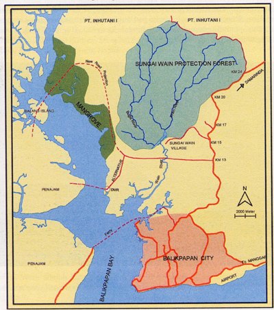 Map showing proposed road and bridge and shorter alternative (larger image at the end of the article). Image courtesy of Stanislav Lhota. |
"The destruction of the mangroves will also impact the fragile marine wildlife in the [Balikpapan] bay and fisheries due to destruction of fish breeding areas," adds Dr. Danielle Kreb of the local NGO RASI, who has studied the marine mammals in Balikpapan Bay for several years and noticed that the Irrawaddy dolphins’ core habitat is in the vicinity of Pulau Balang.
Despite the clear environmental impact outlined by conservationists, the provincial and federal governments support the project. Local governments, however, have signalled over the past couple months that they oppose the project, especially since there is an alternative plan that would threaten none of the ecosystems, and in addition provide a far shorter route between Penajam to Balikpapan.
A lost wilderness?
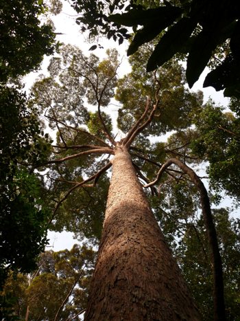 Sungai Wain protected forest. Photo by: Marian Bartos. |
If the Pulau Bridge project goes ahead, Balikpapan Bay will be forever changed. The already shallow bay will face erosion and sedimentation from construction work on the surrounding hills, making the bay less accessible for large boats and leading to more frequent flooding of the coastal villages. Species in the bay, such as dugongs, crocodiles, and green sea turtles—already affected by sedimentation—would likely face further impacts from pollution.
The mangroves—an ecosystem that has faced heavy losses worldwide—would be severely impacted as well. The green corridors allowing species to move between the mangrove ecosystem and the Sungai Wain protection forest will be altogether broken.
"Fauna such as proboscis monkeys and many other species cannot survive in long term in mangroves alone," Lhota explains. "They need regular access to the neighboring forest where they find numerous key resources. Mangroves alone are rather inhospitable environment with only limited food sources. If they are isolated from other forests, they may apparently survive but they will gradually turn into a lifeless stand of Rhizophora trees."
The eventual loss of the mangroves also threatens the local fishing trade since fish require the mangrove forest for breeding: the mangrove stand in question is the last place for fish in the bay to breed.
"East Kalimantan only has a small mangrove area left, because much of the mangrove area [has] already [been] converted to shrimp ponds and industry. And on Balikpapan, [this] is [the] last mangrove forest," says Ade Fadli of BEBSiC, a local conservation group.
The road connecting the bridge to Balikpapan would next pass along the western edge of the Sungai Wain forest reserve, the last major stand of dipterocarp trees along the south and central coast. While the direct impact of road building to the forest reserve would likely be minimal, the road would open the reserve to "illegal logging, land clearance, and above all, forest fires," according to Lhota.
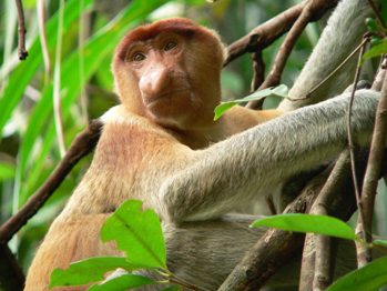 A female proboscis monkey. It is estimated that 5 percent of the world's proboscis monkeys are in the mangroves around Balikpapan bay. Photo by: Petr Colas. |
"The [Sungai Wain] forest, which was burned only once, regenerates well but becomes highly prone to subsequent fires due to the decrease in humidity and huge quantities of highly flammable dead wood," Lhota explains. "If it burns a second time, it can no longer regenerate easily. With the current tendency of governments to consider such forest as 'lost forever', it is likely to be doomed to further encroachment and conversion."
Home to over 100 mammal species and over 250 bird species, the loss of the forest would devastate tropical species, including a population of reintroduced orangutans.
In addition, the forest is as a catchment source of clean water for the state-owned oil company Pertamina, and the Kariangau Baru industrial area. The loss of the forest would endanger the water needs of these industries, which uses it for cooling in refineries and drinking for employees.
The Sungai Wain forest "is the last watershed covered with forest and hence supplying freshwater on an ongoing basis. The water from this reserve has been used for the oil industry and its workers/households (which make up almost 20 percent of the population in Balikpapan) since 1945," Fredriksson explains.
According to Lhota, Balikpapan Bay has huge ecotourism and education potential which has largely gone untapped.
Not much left
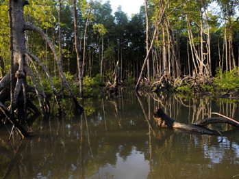 Mangroves of Balikpapan bay. Photo by: Petr Slavik. |
The process of slow destruction by human impacts has already begun in Sungai Wain forest, which is threatened by a road being constructed along its southern side.
"There is a lot of illegal logging going on freely along the road, land is being opened fast by felling and burning and first small houses started to appear on the both sides of the road. This is an uncontrollable process," says Lhota. Despite government promises of better monitoring, increased law enforcement, and protections of the forest, "in practice, no protected area along a provincial road in East Kalimantan was able to survive."
A number of species in the area are threatened with extinction worldwide. The bay cat, flat-headed cat, Bornean orangutan, storm's stork, Bornean gibbon, proboscis monkey, and Bornean peacock pheasant are all listed as Endangered by the IUCN Red List.
The forest is also home to the white-fronted langur, an elusive primate who was only photographed for the first time in 2005. Most of the existing photographs are from the Sungai Wain forest.
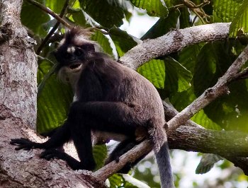 White-fronted lanngur in the Sungai Wain forest. Photo by: Milan Janda. |
For Fredriksson, who studies the sun bear, classified as Vulnerable, the project would severely impact the local population she has spent years studying.
"It will isolate even further an already fragile and small population of sun bears, ironically the mascot of the [Balikpapan] district since 2004. It will destroy the home-ranges of several bears, it will further increase poaching of bears (through snares) […]" Fredriksson says. "I would estimate that the population of sun bears will be halved due to this road and will make the population highly prone to much quicker extinction."
Alternative route
This doesn't have to happen. According to conservationists, a simple alternative route exists that would preserve the bay, mangroves, and forest. The alternative would also be a quicker route for the local people to drive between Balikpapan and Penajam. Under the current plan one will have to drive an additional 80 kilometers between Penajam and Balikpapan, which would take longer than simply taking the already-available ferry service. The alternative projects calls for bridge and road to be built at the very southern edge of the bay, completely bypassing the mangroves and the rainforest. Perhaps most important for the politicians, while the alternative plan would cost more upfront, it will prove cheaper in the long run.
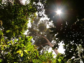 Sungai Wain forest. Photo by: Marian Bartos. |
In addition to environmental costs, the project ignores higher maintenance costs since the road will be built on land-slide prone hills and will be considerably longer than the alternative. The economic cost of local industries losing dependable water source has also not been calculated. While the alternative route is more expensive upfront, in the long-term it will likely prove considerably cheaper compared to the Pulau Balang bridge
A second alternative would be to skip new road building altogether and simply improve the ferry transport between Balikpapan and Penajam while enhancing existing roads.
While the Pulau Balang Bridge project has undergone an Environmental Impact Assessment (EIA), Lhota says the EIA is hardly satisfactory.
"My assistants and I spent one month in the area by voluntarily collecting data to be included in EIA but nothing of it was used. Given the nature of the data, the EIA document overlooks many of the principal threats to the area, such as the threat of fires to the Sungai Wain Protection Forest, the threat of extinction of mangrove fauna due to its isolation from the other forests and many others. […] Furthermore, the EIA document is hardly available (it took me four years to get a copy of it and almost no other conservationists have ever accessed it) and it is practically never consulted […] It is clear that the only purpose for conducting EIA study was to fulfil the legal requirement of having an EIA document and not to evaluate the environmental impact assessment of the project."
Going forward: local versus provincial and federal
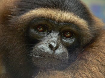 The Bornean gibbon is listed as Endangered by the IUCN Red List. Photo by: Petr Colas. |
As Ade Fadli explains: "local people only want to get [the] best transportation facilities."
Yet the provincial and federal governments remain staunch supporters, capable of pushing the Pulau Balang Bridge through despite local concerns. Already, funds for the bridge and road have been secured by investors from South Korea.
"The provincial government simply ignores the environmental issues. They claim that there is a need to improve transportation between East and South Kalimantan, which is right, but it does not explain why to select the Pulau Balang Bridge variant of the provincial road in favor of any of the several suggested alternatives," Fredriksson says.
Behind some of the government's support could be corruption: many individuals strand to gain hefty government payouts for land speculation.
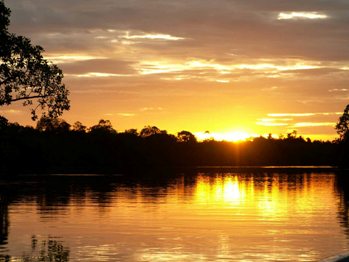 Sunset over the mangroves. Photo by: Stanislav Lhota. |
"I currently do not know who all bought the land along the proposed provincial road but these people are probably very influential, and, of course, highly motivated stakeholders. Corruption is an integral part of Indonesian culture and local rumors explain some of the government’s decisions in this light," an anonymous source said, adding that, "of course, these rumors cannot be proved."
In the end the building of the road would be another loss in a long list of losses for Indonesian biodiversity and forests. The island nation—which has one of the largest deforestation rates in the world, losing nearly 25 percent of its forest in 15 years—is the third largest emitter of greenhouse gases after China and the United States almost entirely due to carbon emissions related to deforestation. In addition, the island of Borneo has lost nearly 50 percent of its forest cover since the 1970s, despite increasing understanding of the importance of rainforests for ecological services like carbon sequestration, biodiversity preservation, and freshwater catchments.
Despite Indonesia's disturbing history, conservationists hope that this time the provincial and federal governments will come around and see that ensuring the preservation of the forest reserve—not to mention the mangroves and the bay itself—is the best way forward both environmentally and economically.
A few notable species in the area:
Mammals:
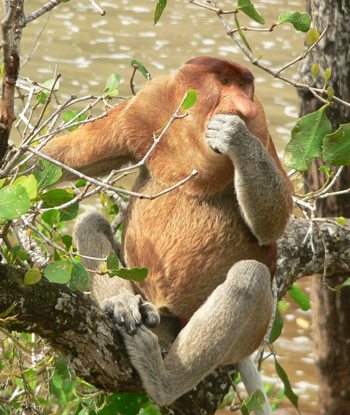 Male proboscis monkey. Photo by: Petr Colas. |
Bay cat (Pardofelis badia)
Bornean orangutan (Pongo pygmaeus)
Bornean gibbon (Hylobates muelleri)
Flat-headed cat (Prionailurus planiceps)
Proboscis monkey (Nasalis larvatus)
Vulnerable:
Bornean slow loris (Nycticebus menagensis)
Dugong ( Dugong dugon)
Irrawaddy Dolphin ( Orcaella brevirostris)
Marbled cat (Pardofelis marmorata)
Pig-tailed macaque (Macaca nemestrina)
Sun Bear (Helarctos malayanus)
Sunda clouded leopard (Neofelis diardi)
Western tarsius (Tarsius bancanus)
White-fronted langur (Presbytis frontata)
Least Concern:
Maroon langur (Presbytis rubicunda)
Leopard cat (Prionailurus benhalensis)
Long-tailed macaque (Macaca fascicularis)
Silvered langur (Trachypithecus cristatus)
Birds:
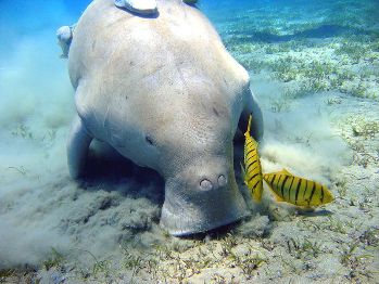 The Dugong is listed as Vulnerable by the IUCN Red List. Photo by: Julien Willem. |
Bornean Peacock Pheasant (Polyplectron schleiermacheri )
Storm's Stork (Ciconia stormi)
Vulnerable:
Blue-headed Pitta (pitta baudii)
Bornean Wren-babbler (Ptilocichla leucogrammica)
Near Threatened:
Bornean Bristlehead ( Pityriasis gymnocephala)
Bornean Ground Cukoo ( Carpococcyx radiceus)
Reptiles/Amphibians:
Endangered:
False gavials, reports of a few surviving individuals (Tomistoma schlegelii)
Green sea turtles (Chelonia mydas)
Least Concern:
Saltwater Crocodile ( Crocodylus porosus)

Map of provincial road and bridge, as well as alternative. Image courtesy of Stanislav Lhota.
Source
No comments:
Post a Comment